

 Volver
Mostrar el registro sencillo del ítem
[A_Armentia_SanPrudencio] Documentación geométrica de la Basílica de Armentia (Vitoria-Gasteiz, Álava)
| dc.contributor.author | Aizpitarte Odria, Ibon | |
| dc.contributor.author | Irizábal González, Diego | |
| dc.contributor.author | Lopetegi Galarraga, Ane  | |
| dc.contributor.author | Mesanza Moraza, Amaia | |
| dc.contributor.author | Rodriguez-Miranda, Alvaro | |
| dc.contributor.author | Valle Melón, José Manuel | |
| dc.coverage.spatial | Basílica de San Prudencio de Armentia (Vitoria-Gasteiz) | |
| dc.coverage.spatial | Vitoria-Gasteiz, Álava, España/Spain (Getty TGN: 7008811) // Armentia (Getty TGN: 7346161) | |
| dc.coverage.temporal | 2004 | |
| dc.date.accessioned | 2013-06-28T17:21:12Z | |
| dc.date.available | 2013-06-28T17:21:12Z | |
| dc.date.issued | 2004-04 | |
| dc.identifier.citation | Laboratorio de Documentación Geométrica del Patrimonio (Universidad del País Vasco-Euskal Herriko Unibertsitatea UPV/EHU) –LDGP-. Documentación geométrica de la Basílica de Armentia (Vitoria-Gasteiz, Álava). 2004 | es |
| dc.identifier.uri | http://hdl.handle.net/10810/10380 | |
| dc.description | [ES] La documentación contenida en este registro ha servido de base para el siguiente proyecto fin de carrera: | es |
| dc.description | ● LDGP_pfc_007: "Fotogrametría digital aplicada a la obtención de ortofotos y modelos digitales del entidades patrimoniales", http://hdl.handle.net/10810/8334 | es |
| dc.description | [EN] This project was the source of one bachelor thesis also located in the repository: | en |
| dc.description | ● LDGP_pfc_007: "Digital photogrammetry for the production of orthophotographs and digital elevation models of historic buildings", http://hdl.handle.net/10810/8334 | en |
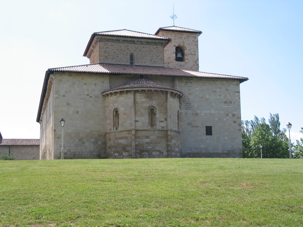
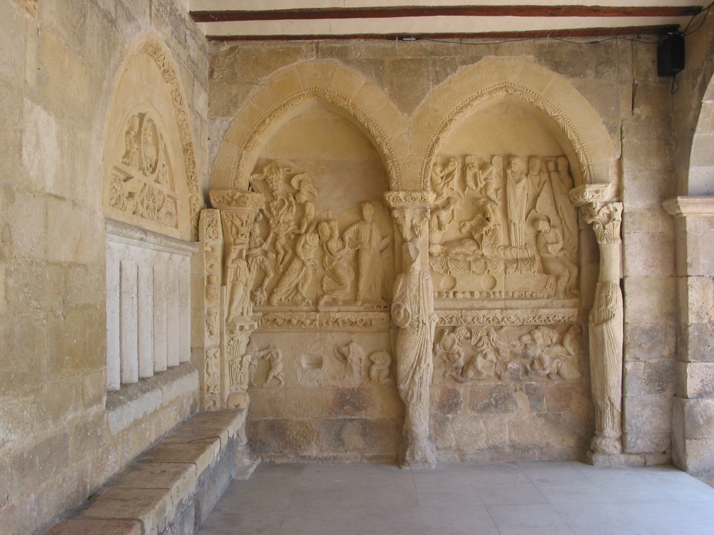
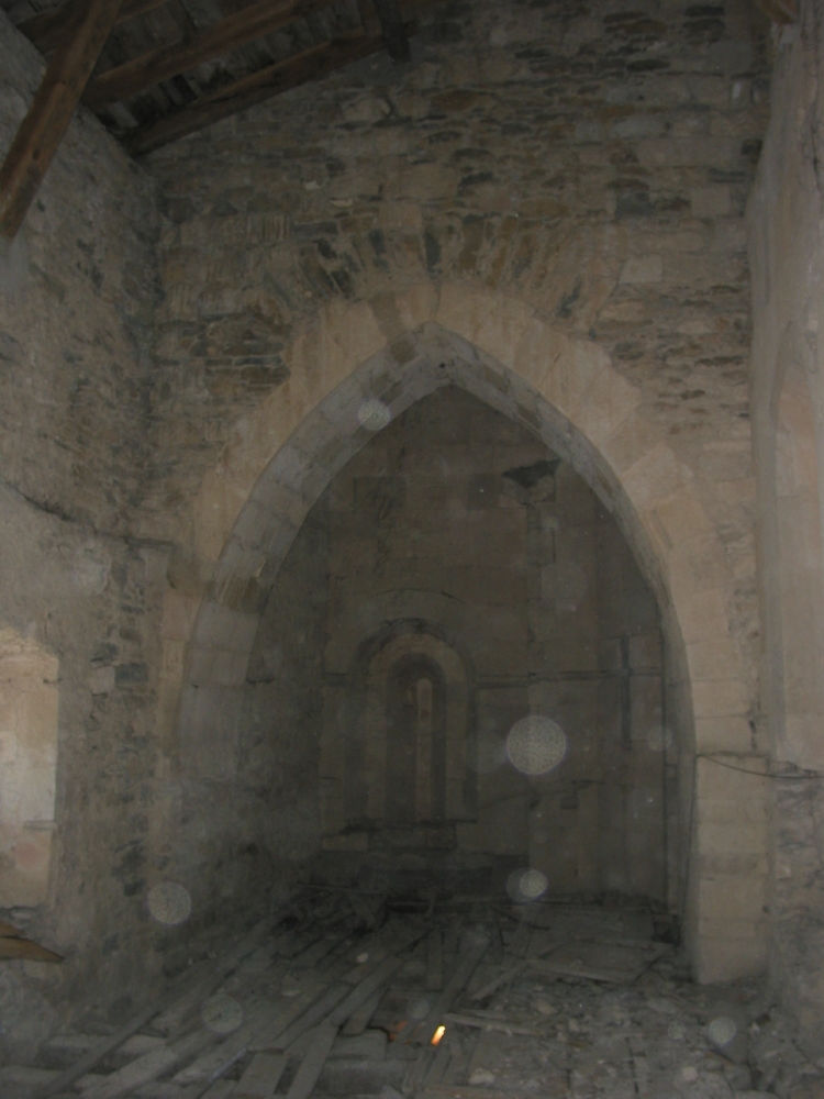
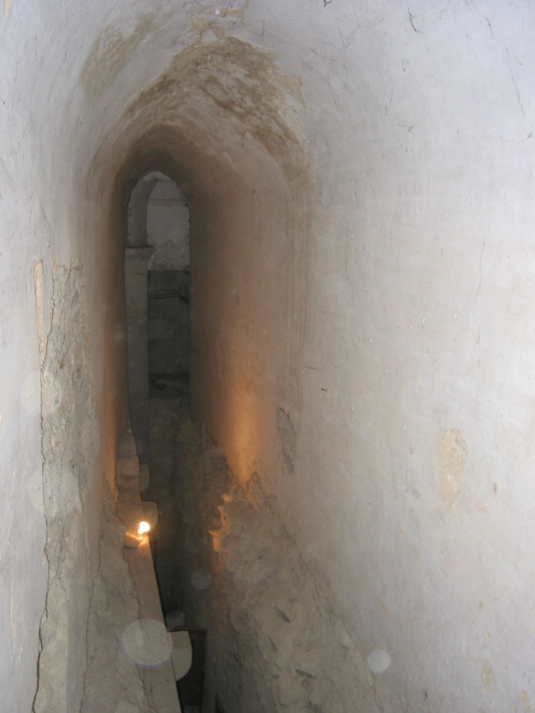
| dc.description.abstract | [ES] Se trata de un edificio románico en piedra que originalmente tenía planta de cruz hasta que en su rehabilitación del siglo XVIII se encerró dentro de un volumen rectangular de unos 20 x 40 metros. Cuenta con torre, cimborrio, ábside semicircular y restos de dependencias conventuales. Inicialmente dedicado a San Andrés, en la actualidad está dedicado a San Prudencio. | es |
| dc.description.abstract | El exterior de la iglesia se ha documentado mediante técnicas fotogramétricas estereoscópicas utilizando fotogramas en película e imágenes digitales. Posteriormente los pares han sido restituidos obteniéndose el volumétrico vectorial que incluye también los relieves escultóricos. Respecto al volumétrico tridimensional del interior, se ha realizado con estación total. Finalmente se ha generado el modelo conjunto y la colección de planos. | es |
| dc.description.abstract | [EN] San Prudencio’s basilica (formely dedicated to San Andrés) was in its origin a Romanesque church with cross-shaped plan. During 18th century an important restoration concealed it inside a rectangular building of around 20 by 40 meters. It has semicircular apse, one tower, dome and some remains of conventual dependencies. | en |
| dc.description.abstract | The outside of the church was documented by stereoscopic photogrammetry (both analogical and digital ones). Pairs were stereoplotted in order to get the wireframe model including the sculptures. On the other hand, the inside part was documented by means of total station. The results include a 3D model and a collection of plan. | en |
| dc.description.sponsorship | Caja Vital Kutxa | es |
| dc.description.tableofcontents | [ES] Memoria del proyecto (106 páginas) en formato PDF + 10 fotografías de documentación (formato JPEG) + modelo alámbrico virtual del pórtico (formato VRML). | es |
| dc.description.tableofcontents | [EN] General report (106 pages in Spanish) format PDF + 10 photographs for documentation purposes (JPEG) + one virtual model (wireframe) of the portico in VRML format. | en |
| dc.language.iso | spa | es |
| dc.publisher | Laboratorio de Documentación Geométrica del Patrimonio (LDGP) | es |
| dc.relation.ispartofseries | LDGP_mem_027-1 | |
| dc.relation.uri | http://hdl.handle.net/10810/8334 | |
| dc.rights | info:eu-repo/semantics/openAccess | es |
| dc.rights.uri | http://creativecommons.org/licenses/by/3.0/ | * |
| dc.subject | patrimonio cultural | es |
| dc.subject | reconocimiento topográfico | es |
| dc.subject | fotogrametría | es |
| dc.subject | edificio religioso | es |
| dc.subject | monumento histórico | es |
| dc.subject | cultural heritage | en |
| dc.subject | surveying | en |
| dc.subject | photogrammetry | en |
| dc.subject | religious buildings | en |
| dc.subject | historic monuments | en |
| dc.title | [A_Armentia_SanPrudencio] Documentación geométrica de la Basílica de Armentia (Vitoria-Gasteiz, Álava) | es |
| dc.title.alternative | Geometric documentation of the basilica of Armentia (Vitoria-Gasteiz, Álava, Spain) | en |
| dc.type | info:eu-repo/semantics/report | es |
| dc.rights.holder | Attribution 3.0 Unported | * |
| dc.coverage.spatiallink | http://maps.google.com/maps?q=42.8331,-2.702 | |
| dc.coverage.spatiallink | http://vocab.getty.edu/tgn/7346161 |
Ficheros en el ítem
![No Thumbnail [100%x80]](data:image/svg+xml;base64,PD94bWwgdmVyc2lvbj0iMS4wIiBlbmNvZGluZz0iVVRGLTgiIHN0YW5kYWxvbmU9InllcyI/PjxzdmcgeG1sbnM9Imh0dHA6Ly93d3cudzMub3JnLzIwMDAvc3ZnIiB3aWR0aD0iMTI2NCIgaGVpZ2h0PSI4MCIgdmlld0JveD0iMCAwIDEyNjQgODAiIHByZXNlcnZlQXNwZWN0UmF0aW89Im5vbmUiPjwhLS0KU291cmNlIFVSTDogaG9sZGVyLmpzLzEwMCV4ODAvdGV4dDpObyBUaHVtYm5haWwKQ3JlYXRlZCB3aXRoIEhvbGRlci5qcyAyLjYuMC4KTGVhcm4gbW9yZSBhdCBodHRwOi8vaG9sZGVyanMuY29tCihjKSAyMDEyLTIwMTUgSXZhbiBNYWxvcGluc2t5IC0gaHR0cDovL2ltc2t5LmNvCi0tPjxkZWZzPjxzdHlsZSB0eXBlPSJ0ZXh0L2NzcyI+PCFbQ0RBVEFbI2hvbGRlcl8xOTYzYzExN2EyYiB0ZXh0IHsgZmlsbDojQUFBQUFBO2ZvbnQtd2VpZ2h0OmJvbGQ7Zm9udC1mYW1pbHk6QXJpYWwsIEhlbHZldGljYSwgT3BlbiBTYW5zLCBzYW5zLXNlcmlmLCBtb25vc3BhY2U7Zm9udC1zaXplOjYzcHQgfSBdXT48L3N0eWxlPjwvZGVmcz48ZyBpZD0iaG9sZGVyXzE5NjNjMTE3YTJiIj48cmVjdCB3aWR0aD0iMTI2NCIgaGVpZ2h0PSI4MCIgZmlsbD0iI0VFRUVFRSIvPjxnPjx0ZXh0IHg9IjM0MC41IiB5PSI2OS40Ij5ObyBUaHVtYm5haWw8L3RleHQ+PC9nPjwvZz48L3N2Zz4=)


![No Thumbnail [100%x80]](data:image/svg+xml;base64,PD94bWwgdmVyc2lvbj0iMS4wIiBlbmNvZGluZz0iVVRGLTgiIHN0YW5kYWxvbmU9InllcyI/PjxzdmcgeG1sbnM9Imh0dHA6Ly93d3cudzMub3JnLzIwMDAvc3ZnIiB3aWR0aD0iMTI2NCIgaGVpZ2h0PSI4MCIgdmlld0JveD0iMCAwIDEyNjQgODAiIHByZXNlcnZlQXNwZWN0UmF0aW89Im5vbmUiPjwhLS0KU291cmNlIFVSTDogaG9sZGVyLmpzLzEwMCV4ODAvdGV4dDpObyBUaHVtYm5haWwKQ3JlYXRlZCB3aXRoIEhvbGRlci5qcyAyLjYuMC4KTGVhcm4gbW9yZSBhdCBodHRwOi8vaG9sZGVyanMuY29tCihjKSAyMDEyLTIwMTUgSXZhbiBNYWxvcGluc2t5IC0gaHR0cDovL2ltc2t5LmNvCi0tPjxkZWZzPjxzdHlsZSB0eXBlPSJ0ZXh0L2NzcyI+PCFbQ0RBVEFbI2hvbGRlcl8xOTYzYzExNWNmOSB0ZXh0IHsgZmlsbDojQUFBQUFBO2ZvbnQtd2VpZ2h0OmJvbGQ7Zm9udC1mYW1pbHk6QXJpYWwsIEhlbHZldGljYSwgT3BlbiBTYW5zLCBzYW5zLXNlcmlmLCBtb25vc3BhY2U7Zm9udC1zaXplOjYzcHQgfSBdXT48L3N0eWxlPjwvZGVmcz48ZyBpZD0iaG9sZGVyXzE5NjNjMTE1Y2Y5Ij48cmVjdCB3aWR0aD0iMTI2NCIgaGVpZ2h0PSI4MCIgZmlsbD0iI0VFRUVFRSIvPjxnPjx0ZXh0IHg9IjM0MC41IiB5PSI2OS40Ij5ObyBUaHVtYm5haWw8L3RleHQ+PC9nPjwvZz48L3N2Zz4=)
![No Thumbnail [100%x80]](data:image/svg+xml;base64,PD94bWwgdmVyc2lvbj0iMS4wIiBlbmNvZGluZz0iVVRGLTgiIHN0YW5kYWxvbmU9InllcyI/PjxzdmcgeG1sbnM9Imh0dHA6Ly93d3cudzMub3JnLzIwMDAvc3ZnIiB3aWR0aD0iMTI2NCIgaGVpZ2h0PSI4MCIgdmlld0JveD0iMCAwIDEyNjQgODAiIHByZXNlcnZlQXNwZWN0UmF0aW89Im5vbmUiPjwhLS0KU291cmNlIFVSTDogaG9sZGVyLmpzLzEwMCV4ODAvdGV4dDpObyBUaHVtYm5haWwKQ3JlYXRlZCB3aXRoIEhvbGRlci5qcyAyLjYuMC4KTGVhcm4gbW9yZSBhdCBodHRwOi8vaG9sZGVyanMuY29tCihjKSAyMDEyLTIwMTUgSXZhbiBNYWxvcGluc2t5IC0gaHR0cDovL2ltc2t5LmNvCi0tPjxkZWZzPjxzdHlsZSB0eXBlPSJ0ZXh0L2NzcyI+PCFbQ0RBVEFbI2hvbGRlcl8xOTYzYzExYWQ1ZCB0ZXh0IHsgZmlsbDojQUFBQUFBO2ZvbnQtd2VpZ2h0OmJvbGQ7Zm9udC1mYW1pbHk6QXJpYWwsIEhlbHZldGljYSwgT3BlbiBTYW5zLCBzYW5zLXNlcmlmLCBtb25vc3BhY2U7Zm9udC1zaXplOjYzcHQgfSBdXT48L3N0eWxlPjwvZGVmcz48ZyBpZD0iaG9sZGVyXzE5NjNjMTFhZDVkIj48cmVjdCB3aWR0aD0iMTI2NCIgaGVpZ2h0PSI4MCIgZmlsbD0iI0VFRUVFRSIvPjxnPjx0ZXh0IHg9IjM0MC41IiB5PSI2OS40Ij5ObyBUaHVtYm5haWw8L3RleHQ+PC9nPjwvZz48L3N2Zz4=)
Este ítem aparece en la(s) siguiente(s) colección(ones)

Excepto si se señala otra cosa, la licencia del ítem se describe como Attribution 3.0 Unported